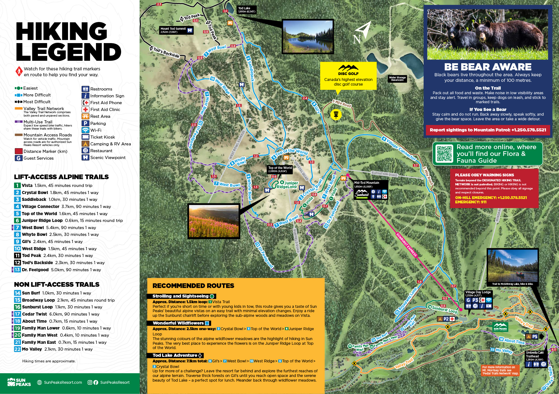
#1. Vista
1.5km, 30 minutes, round trip – Vista traverses through sub-alpine woods and the edge of the mountainside meadows. The bottom half is relatively flat and can be an easy out-and-back or, with a short uphill to the top section, make it a loop.
#6. Juniper Ridge Loop
0.6km, 15 minutes, round trip – This easy, must-do loop is the reward for reaching Top of the World. Enjoy the sights and aromas of densely growing wildflowers and the best viewpoint of the region.
#16. Sunburst Loop
1.1 km, 30 minutes, round trip – Explore the lower reaches of Mt. Tod without straying far from village amenities.
#19. Family Man Lower
0.6km, 10 minutes, one way – This is a multi-use trail built and maintained by the Sun Peaks Recreational Trail Association (SPRTA). Please watch for mountain bikers.
#2. Crystal Bowl
1.8km, 45 minutes, round trip – Branching off of Vista, the Crystal Bowl climbs into and then traverses the wildflower meadows of lower Crystal Bowl. Return via Vista or back the same way.
#3. Saddleback
1km, 30 minutes, one way – This trail traverses the bowl between Top of the World and the base of Tod Peak. giving you a quicker option for accessing Tod Lake and Tod Peak while showcasing spectacular views.
#4. Village Connector
3.7km, 90 minutes, one way – Watch for resort vehicles and mountain bikers while travelling back to the village on this multi-use roadway.
#5. Top of the World
1.6km, 45 minutes, one way – A gentle, yet uphill, back and forth traverse through the Headwalls meadows to connect to the iconic #6 Juniper Ridge Loop.
#7. West Bowl
5.4km, 90 minutes, one way – A scenic route with a gentle climb through wildflower meadows and forested sections out to Tod Lake. This multi-use trail is also the route of the West Bowl XC mountain bike trail, so please watch for riders.
#8. Whyte Bowl
2.5km, 30 minutes, one way – A connector between West Bowl and Top of the World trails that encircles the lower reaches of many classic ski runs off the Burfield chairlift.
#9. Gil's
2.4km, 45 minutes, one way – Wind through the forested slopes of the ski terrain that bears the same name – this is the shortest route to Tod Lake. Or, use it as your return trail if you accessed the lake via #7.
#10. West Ridge
1.5km, 45 minutes, one way – Follow this meandering trail to access Tod Lake and #11 Tod Peak trail while enjoying vast, open meadows and panoramic views of the upper reaches of Tod Mountain.
#15. Broadway Loop
2.1km, 45 minutes, round trip – Access from Sunburst Loop to meander up and across lower sections of favourite ski runs.
#17. Cedar Twist
6km, 90 minutes, one way – Enjoy a hike to the top of Mt. Morrisey through beautiful cedar forest, with fantastic views of Mt. Tod and Sundance along the way. This is a multi-use trail built and maintained by the Sun Peaks Recreational Trail Association (SPRTA). Please watch for mountain bikers.
#13. Dr. Feelgood
5.0km, 90 minutes, one way – This is a multi-use trail, please watch for riders.
#18. About Time
0.7km, 15 minutes, one way – This is a multi-use trail built and maintained by the Sun Peaks Recreational Trail Association (SPRTA). Please watch for mountain bikers.
#20. Family Man West
0.4km, 10 minutes, one way – This is a multi-use trail built and maintained by the Sun Peaks Recreational Trail Association (SPRTA). Please watch for mountain bikers.
#21. Family Man East
0.7km, 15 minutes, one way – This is a multi-use trail built and maintained by the Sun Peaks Recreational Trail Association (SPRTA). Please watch for mountain bikers.
#22. Mo Valley
2.1km, 30 minutes, one way – A wide, double-track trail from the base of the Morrisey Express chairlift to Mountain View Drive. This is a multi-use route; please watch for mountain bikers.
#14. SunBurf
1km, 30 minutes, one way – This is a multi-use trail built and maintained by the Sun Peaks Recreational Trail Association (SPRTA). Please watch for mountain bikers.
#11. Tod Peak
2.4km, 30 minutes, one way – Conquer the 2,152m (7,060ft) summit of Mt. Tod and drink in the 360° views from Sun Peaks’ highest point! Allow five hours to complete the full route from the mid-mountain trailheads.
#12. Tod's Backside
2.3km, 30 minutes, one way – Extend your alpine exploration with this trail that meanders around the Mt. Tod summit.
There are no results for your selection, please try again.